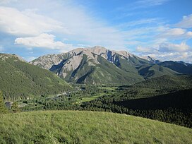
| Livingstone Range | |
|---|---|
 NW face of Thunder Mountain | |
| Highest point | |
| Peak | Centre Peak |
| Elevation | 2,549 m (8,363 ft)[1][2] |
| Listing | Mountains of Alberta |
| Coordinates | 49°56′35″N 114°20′07″W / 49.942944°N 114.335306°W[3] |
| Geography | |
| Country | Canada |
| Province | Alberta |
| Parent range | Canadian Rockies (Southern Continental Ranges) |
| Topo map | NTS 82G9 Blairmore[3] |
The Livingstone Range is a sub-range of the Canadian Rockies in Alberta, Canada. It forms the eastern boundary of the Rockies in the south of the province. Its northern boundary is the Highwood River and it extends to Crowsnest Pass in the south. The Livingstone and Oldman Rivers bound it to the west.
- ^ "Centre Peak". cdnrockiesdatabases.ca. Retrieved 2023-08-14.
- ^ "Topographic map of Centre Peak". opentopomap.org. Retrieved 2023-08-14.
- ^ a b "Livingstone Range". Geographical Names Data Base. Natural Resources Canada. Retrieved 2023-08-14.
