Livno | |
|---|---|
| Grad Livno Град Ливнo City of Livno | |
 | |
 Location of Livno within Bosnia and Herzegovina | |
| Coordinates: 43°49′31″N 17°00′21″E / 43.82528°N 17.00583°E | |
| Country | |
| Entity | Federation of Bosnia and Herzegovina |
| Canton | Canton 10 |
| Geographical region | Tropolje |
| First mentioning | 28 September 892 CE |
| Government | |
| • Mayor | Darko Čondrić (HDZ BiH) |
| Area | |
| • Municipality | 994 km2 (384 sq mi) |
| Elevation | 724 m (2,375 ft) |
| Population (2013) | |
• Total | 34,133 |
| • Density | 38/km2 (100/sq mi) |
| • Town | 7,927 |
| Time zone | UTC+1 (CET) |
| • Summer (DST) | UTC+2 (CEST) |
| Postal code | 80101 |
| Area code | +387 34 |
| Website | livno |
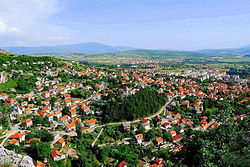
Livno (Serbian Cyrillic: Ливно, pronounced [lǐːʋno]) is a city and the administrative center of Canton 10 of the Federation of Bosnia and Herzegovina, an entity of Bosnia and Herzegovina. It is situated on the river Bistrica in the southeastern edge of the Livno Field at the foot of Kruzi plateau which are located beneath the Cincar mountain and rocky hill Crvenice. Livno is the centre of the Canton 10 which mainly covers an area of the historical and geographical region of Tropolje.[1][2] As of 2013, it has a population of 37,487 inhabitants. The town, with its historic ruins and old town from the 9th century, was first mentioned in 892, developing at the crossroads between the Adriatic coast and inland, i.e., regions of Bosnia, Dalmatia, Herzegovina, and Krajina.[3]
- ^ "Livno". enciklopedija.hr. Miroslav Krleža Institute of Lexicography. Retrieved 8 June 2016.
- ^ "Stari grad u Livnu (Bistrički grad), historijsko područje". Bosnia and Herzegovina Commission to Preserve National Monuments. Retrieved 8 June 2016.
- ^ "Livno". proleksis.lzmk.hr. Miroslav Krleža Institute of Lexicography. Retrieved 8 June 2016.


