Llano County | |
|---|---|
 | |
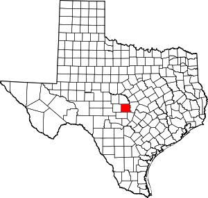
 Location within the U.S. state of Texas | |
 Texas's location within the U.S. | |
| Coordinates: 30°43′N 98°41′W / 30.71°N 98.68°W | |
| Country | |
| State | |
| Founded | 1856 |
| Named for | Llano River |
| Seat | Llano |
| Largest city | Horseshoe Bay |
| Area | |
| • Total | 966 sq mi (2,500 km2) |
| • Land | 934 sq mi (2,420 km2) |
| • Water | 32 sq mi (80 km2) 3.3% |
| Population (2020) | |
| • Total | 21,243 |
| • Density | 22/sq mi (8.5/km2) |
| Time zone | UTC−6 (Central) |
| • Summer (DST) | UTC−5 (CDT) |
| Congressional district | 11th |
| Website | www |
Llano County (/ˈlænoʊ/) is a county located on the Edwards Plateau in the U.S. state of Texas. As of the 2020 census, its population was 21,243.[1] Its county seat is Llano,[2] and the county is named for the Llano River.


- ^ "Llano County, Texas". United States Census Bureau. Retrieved February 23, 2021.
- ^ "Find a County". National Association of Counties. Retrieved June 7, 2011.