| Loch Davan | |
|---|---|
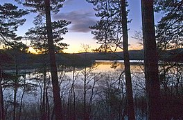
 Dawn at Loch Davan | |
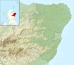
| Location | Grampian, Scotland |
| Coordinates | 57°5′40″N 2°55′23″W / 57.09444°N 2.92306°W[1] |
| Type | freshwater loch |
| Primary inflows | Red Burn and Logie Burn[2] |
| Primary outflows | Monandavan Burn [2] |
| Basin countries | Scotland |
| Max. length | 0.75 mi (1.21 km)[3] |
| Max. width | 0.33 mi (0.53 km)[3] |
| Surface area | 42.2 ha (104 acres)[1] |
| Average depth | 4 ft (1.2 m)[3] |
| Max. depth | 9 ft (2.7 m)[3] |
| Water volume | 25,000,000 cu ft (710,000 m3)[3] |
| Shore length1 | 3.3 km (2.1 mi)[1] |
| Surface elevation | 167 m (548 ft)[1] |
| Islands | 0[1] |
| 1 Shore length is not a well-defined measure. | |
Loch Davan is a small, triangular, freshwater loch approximately 5 mi (8.0 km) northeast of Ballater, Scotland and lying immediately north of Loch Kinord. It is approximately 0.75 mi (1.21 km) in length and was formed from a glacial kettle hole.[2][4] The loch sits within the Muir of Dinnet National Nature Reserve.[2]
- ^ a b c d e "Loch Davan". British lakes. British Lakes. Retrieved 2 January 2015.
- ^ a b c d "The story of Muir of Dinnet National Nature Reserve" (PDF). Scotland's National Nature Reserves. Retrieved 2 January 2015.
- ^ a b c d e "Bathymetrical Survey of the Fresh-Water Lochs of Scotland, 1897-1909, Lochs of the Dee (Aberdeen) Basin". National Library of Scotland. Retrieved 2 January 2015.
- ^ "Davan, Loch". Gazetteer of Scotland. Retrieved 2 January 2015.
