| Loch Ryan Loch Rìoghaine | |
|---|---|
 Aerial view of Loch Ryan. | |
| Location | Scottish Lowlands, Scotland |
| Coordinates | 54°59′10″N 5°03′18″W / 54.986°N 5.055°W |
| Type | Sea loch |
| Primary inflows | Water of App, Glen Burn |
| Primary outflows | North Channel |
| Catchment area | 197 km2 (76 sq mi)[1] |
| Basin countries | Scotland |
| Max. length | 13.4 kilometers (8.3 mi)[1] |
| Max. depth | 16 m (52 ft)[1] |
| Surface elevation | 0 m (0 ft) |
| Settlements | Stranraer, Cairnryan, Kirkcolm |
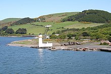
| Loch Ryan Lighthouse Cairnryan Point | |
 Cairn Point lighthouse viewed from the southwest in 2009 | |
| Coordinates | 54°58′28″N 5°01′51″W / 54.974468°N 5.030861°W |
| Constructed | 1847 |
| Construction | masonry tower |
| Automated | 1964 |
| Height | 15 metres (49 ft) |
| Shape | cylindrical tower with balcony and lantern attached to 1-storey keeper’s house |
| Markings | white tower, black lantern, ochre trim |
| Power source | mains electricity |
| Operator | Northern Lighthouse Board[2][3] |
| Heritage | category B listed building |
| Focal height | 14 metres (46 ft) |
| Range | 12 nautical miles (22 km; 14 mi) |
Loch Ryan (Scottish Gaelic: Loch Rìoghaine, pronounced [l̪ˠɔx ˈrˠiː.ɛɲə]) is a Scottish sea loch that acts as an important natural harbour for shipping, providing calm waters for ferries operating between Scotland and Northern Ireland. The town of Stranraer is the largest settlement on its shores, with ferries to and from Northern Ireland operating from Cairnryan further north on the loch.
- ^ a b c Scottish Environment Protection Agency "Shellfish Growing Areas, Loch Ryan", accessed 16 March 2011
- ^ Rowlett, Russ. "Lighthouses of Southwestern Scotland". The Lighthouse Directory. University of North Carolina at Chapel Hill. Retrieved 17 May 2016.
- ^ Loch Ryan Light Lighthouse Explorer. Retrieved 17 May 2016
