| Loch Tummel | |
|---|---|
 The 'Queen's View' | |
| Location | Perth and Kinross, Scotland |
| Coordinates | 56°42′39″N 3°55′44″W / 56.7107°N 3.9290°W |
| Type | freshwater loch |
| Basin countries | Scotland |
| Max. length | 11 km (7 mi)[1] |
| Max. width | 0.95 km (0.59 mi)[1] |
| Surface area | 579.1 ha (1,431 acres)[2] |
| Max. depth | 44 m (145 ft)[1] |
| Shore length1 | 27.2 km (16.9 mi) [2] |
| Surface elevation | 142 m (466 ft)[2] |
| 1 Shore length is not a well-defined measure. | |
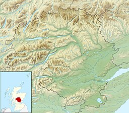
Loch Tummel (Scottish Gaelic: Loch Teimheil) is a long, narrow loch, seven kilometres (4+1⁄2 miles) northwest of Pitlochry in the council area of Perth and Kinross, Scotland. It is fed and drained by the River Tummel, which flows into the River Tay about 13 km (8 mi) south-east of the Clunie Dam at the loch's eastern end.[3][4][2]
The loch is traversed by roads to both north and south. Along the northern side the road is numbered as the B8019, and runs from the Pass of Killiecrankie on the A9 in the east to Tummel Bridge at the head of the loch. The road on the southern side is unclassified, and meets the A9 further south, near to Pitlochry.[3]
The loch gives its name to the Loch Tummel National Scenic Area (NSA), one of 40 such areas in Scotland, which are defined so as to identify areas of exceptional scenery and to ensure its protection by restricting certain forms of development.[5] The Loch Tummel Lyon NSA covers 9,013 hectares (22,272 acres), all of which lies within Perth and Kinross.[6] The NSA covers the hills surrounding the loch, and extends along the River Tummel to also take in the area surrounding the Pass of Killiecrankie on the River Garry.[7]
- ^ a b c Cite error: The named reference
weirwas invoked but never defined (see the help page). - ^ a b c d "Loch Tummel". British Lakes. Archived from the original on 24 July 2018. Retrieved 24 July 2018.
- ^ a b Ordnance Survey. Explorer Map 1:25000. Sheet OL49, Pitlochry & Loch Tummel.
- ^ John, Murray; Lawrence, Pullar (1910). Bathymetrical Survey of the Fresh-Water Lochs of Scotland, 1897-1909 Lochs of the Tay Basin Volume II - Loch Tumme. National Library of Scotland: National Challenger Officer. p. 78. Retrieved 24 July 2018.
 This article incorporates text from this source, which is in the public domain.
- ^ "National Scenic Areas". NatureScot. Retrieved 6 October 2020.
- ^ "National Scenic Areas - Maps". Scottish Natural Heritage. 20 December 2010. Archived from the original on 12 June 2018. Retrieved 2 May 2018.
- ^ "Loch Tummel National Scenic Area". NatureScot. Retrieved 6 October 2020.
