Lock Haven, Pennsylvania | |
|---|---|
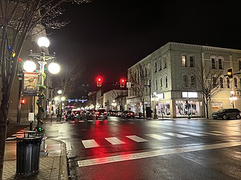
 Downtown Lock Haven at night at the intersection of East Main Street and North Grove Street | |
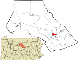
 Location of Lock Haven in Clinton County, Pennsylvania (right) and of Clinton County in Pennsylvania (left) | |
Location of Lock Haven in Pennsylvania Location in the United States | |
| Coordinates: 41°08′16″N 77°27′03″W / 41.13778°N 77.45083°W[1] | |
| Country | United States |
| State | Pennsylvania |
| County | Clinton County |
| Settled | 1769 |
| Incorporated (borough) | 1844 |
| Incorporated (city) | 1870 |
| Government | |
| • Type | Council-Manager |
| • Mayor | Joel Long (D) |
| • Manager | Gregory J. Wilson |
| Area | |
| • Total | 2.67 sq mi (6.91 km2) |
| • Land | 2.50 sq mi (6.47 km2) |
| • Water | 0.17 sq mi (0.44 km2) 6.44% |
| Elevation | 561 ft (171 m) |
| Population | |
| • Total | 8,108 |
| • Density | 3,248.40/sq mi (1,254.00/km2) |
| Time zone | UTC-5 (EST) |
| • Summer (DST) | UTC-4 (EDT) |
| ZIP Code | 17745 |
| Area code(s) | 570 and 272 |
| FIPS code | 42-44128 |
| Website | lockhavenpa lockhaven |
Lock Haven is the county seat of Clinton County, in the U.S. state of Pennsylvania. Located near the confluence of the West Branch Susquehanna River and Bald Eagle Creek, it is the principal city of the Lock Haven Micropolitan Statistical Area, itself part of the Williamsport–Lock Haven combined statistical area. At the 2020 census, Lock Haven's population was 8,108.
Built on a site long favored by pre-Columbian peoples, Lock Haven began in 1833 as a timber town and a haven for loggers, boatmen, and other travelers on the river or the West Branch Canal. Resource extraction and efficient transportation financed much of the city's growth through the end of the 19th century. In the 20th century, a light-aircraft factory, a college, and a paper mill, along with many smaller enterprises, drove the economy. Frequent floods, especially in 1972, damaged local industry and led to a high rate of unemployment in the 1980s.
The city has three sites on the National Register of Historic Places—Memorial Park Site, a significant pre-Columbian archaeological find; Heisey House, a Victorian-era museum; and Water Street District, an area with a mix of 19th- and 20th-century architecture. A levee, completed in 1995, protects the city from further flooding. While industry remains important to the city, about a third of Lock Haven's workforce is employed in education, health care, or social services.
- ^ a b "City of Lock Haven". Geographic Names Information System (GNIS). United States Geological Survey. August 30, 1990. Retrieved November 9, 2009.
- ^ "ArcGIS REST Services Directory". United States Census Bureau. Retrieved October 12, 2022.
- ^ Cite error: The named reference
USCensusDecennial2020CenPopScriptOnlywas invoked but never defined (see the help page).


