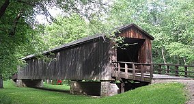
| Locust Creek Covered Bridge State Historic Site | |
|---|---|
 | |
| Location | Linn County, Missouri, United States |
| Nearest city | Meadville |
| Coordinates | 39°47′30″N 93°14′03″W / 39.79167°N 93.23417°W |
| Area | 32.22 acres (13.04 ha)[1] |
| Established | 1968[2] |
| Visitors | 6,307 (in 2022)[3] |
| Operator | Missouri Department of Natural Resources |
| Website | Locust Creek Covered Bridge State Historic Site |
Locust Creek Covered Bridge | |
| Nearest city | Meadville, Missouri |
| Area | 9.9 acres (4.0 ha) |
| Built | 1868 |
| Built by | Bishop & Eaton |
| NRHP reference No. | 70000340 |
| Added to NRHP | May 19, 1970 |
Locust Creek Covered Bridge State Historic Site is a publicly owned property in Linn County, Missouri, maintained as a state historic site by the Missouri Department of Natural Resources.[4] Also called the Linn County Bridge, the covered bridge is located about 3 miles (4.8 km) east of Meadville, Missouri. At a length of 151 feet (46 m) with a width of 16 ft 8 in (5.08 m) it is the longest of the four remaining covered bridges in the state of Missouri. It was listed on the National Register of Historic Places in 1970.[5]
- ^ Cite error: The named reference
parkdatawas invoked but never defined (see the help page). - ^ Cite error: The named reference
acquisitionwas invoked but never defined (see the help page). - ^ "Missouri State Park Attendance For January - December, 2022" (PDF). Missouri State Parks. February 3, 2023.
- ^ Cite error: The named reference
MSPwas invoked but never defined (see the help page). - ^ Cite error: The named reference
nrhpwas invoked but never defined (see the help page).

