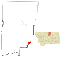
Lodge Pole, Montana | |
|---|---|
 Location of Lodge Pole, Montana | |
| Coordinates: 48°1′58″N 108°32′9″W / 48.03278°N 108.53583°W | |
| Country | United States |
| State | Montana |
| County | Blaine |
| Area | |
| • Total | 13.39 sq mi (34.68 km2) |
| • Land | 13.39 sq mi (34.68 km2) |
| • Water | 0.00 sq mi (0.00 km2) |
| Elevation | 3,409 ft (1,039 m) |
| Population (2020) | |
| • Total | 294 |
| • Density | 21.96/sq mi (8.48/km2) |
| Time zone | UTC-7 (Mountain (MST)) |
| • Summer (DST) | UTC-6 (MDT) |
| Area code | 406 |
| FIPS code | 30-44350 |
| GNIS feature ID | 0773540 |
Lodge Pole is a census-designated place (CDP) in Blaine County, Montana, United States. The population was 265 at the 2010 census.[2] It lies within the Fort Belknap Indian Reservation, near the reservation's southern end.
The nearby community of Hays lies to its west-southwest.
- ^ "ArcGIS REST Services Directory". United States Census Bureau. Retrieved September 5, 2022.
- ^ "Geographic Identifiers: 2010 Demographic Profile Data (G001): Lodge Pole CDP, Montana". U.S. Census Bureau, American Factfinder. Archived from the original on February 12, 2020. Retrieved June 26, 2013.