| Loharu State लोहारू रियासत ریاست لوہارو | |||||||
|---|---|---|---|---|---|---|---|
| Princely State of British India | |||||||
| 1803–1947 | |||||||
|
Flag | |||||||
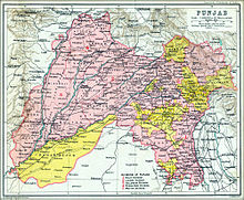
 Loharu at the edge of Punjab (British India), 1903 | |||||||
| Capital | Loharu | ||||||
| Area | |||||||
• 1901 | 570 km2 (220 sq mi) | ||||||
| Population | |||||||
• 1901 | 15,229 | ||||||
| History | |||||||
• Established | 1803 | ||||||
| 1947 | |||||||
| |||||||
| Today part of | India | ||||||
Loharu State was one of the princely states of India during the period of the British Raj.[1] It was part of the Punjab States Agency and was a nine-gun salute state.[citation needed]
Loharu State encompassed an area of 222 square miles (570 km2), and was situated in the south-east corner of the undivided Punjab province, between the district of Hissar and the Rajputana Agency.[2] In 1901, the state had a population of 15,229 people, of whom 2,175 resided in the town of Loharu.[3] From 1803 to 1835, the territory of Loharu State also included an Ferozepur Jhirka enclave within the area directly administered by the British raj,[4][5] Outer limits of the state were defined by the peripheral towns of Loharu, Bahal, Isharwal, Kairu, Jui Khurd and Badhra.
The haveli of 'Nawab of Loharu', known as Mahal Sara, lies in Gali Qasim Jan in Ballimaran, where his son-in-law, noted poet Mirza Ghalib stayed for a few years, whose own Ghalib ki Haveli lies a few yard away.[6][7] Now the gali, which houses the Mahal Sara, is known as Kothi Nawab Loharu lane in Ballimaran mohalla of Chandni Chowk area in Old Delhi.[8]
- ^ Loharu Princely State (nine gun salute)
- ^ 1909 location map of Loharu in British Punjab
- ^ Chisholm, Hugh, ed. (1911). . Encyclopædia Britannica. Vol. 16 (11th ed.). Cambridge University Press. p. 922.
- ^ Sir Thomas Metcalfe. "Assasination [sic] of William Fraser, Agent to the Governor-General of India". British Library. Retrieved 1 February 2014.
- ^ Cite error: The named reference
impwas invoked but never defined (see the help page). - ^ HC fiat to Centre, Delhi Govts on poet Mirza Ghalib's haveli Indian Express, 12 April 1999.
- ^ Delhi Hunger and History in Delhi Archived 8 July 2011 at the Wayback Machine Jauymini Barkataky, Civil Society, April 2007 Edition.
- ^ Senior Secondary Panama Building Girls School in the Kothi Nawab Loharu lane in Ballimaran Indian Express, 8 October 2008.
