Long Island Central Pine Barrens

Long Island Central Pine Barrens
Map showing the location of Long Island Central Pine Barrens
Location of the Long Island Central Pine Barrens
LocationNew York, United States
Nearest cityManorville
Coordinates40°52′48″N 72°44′32″W / 40.87997583809637°N 72.7420901781702°W / 40.87997583809637; -72.7420901781702
Area100,000 acres (400 km2)
Established1993
Governing bodyCentral Pine Barrens Joint Planning and Policy Commission
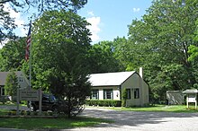
Long Island Pine Barrens Trail office in Manorville, New York

The Long Island Central Pine Barrens (also known as the Long Island Pine Barrens) is a large area of publicly protected pine barrens in Suffolk County, New York, on Long Island, covering more than 100,000 acres (405 km2).

The Barrens operates in a similar manner to Adirondack Park, with public lands managed by a mix of federal, state, county and local public land managers intermixed with private inholdings.

It is Long Island's largest natural area and its last remaining wilderness. The region contains a remnant of the Atlantic coastal pine barrens ecoregion, whose forests might once have covered a quarter million acres (1,000 km2) on Long Island.

The Central Pine Barrens overlays and recharges a portion of a federally designated sole source aquifer for Long Island's drinking water. All of Long Island's drinking water comes from ground water wells; none of the island's water comes from reservoirs. Almost all of the Peconic River and Carmans River (two of Long Island's four biggest rivers) as well as much of their watersheds are in the Barrens.

Two other large, contiguous examples of this ecosystem remain in the northeastern United States: the Massachusetts Coastal Pine Barrens and the New Jersey Pine Barrens.