Long Point, Ontario | |
|---|---|
Unincorporated hamlet in Norfolk County | |
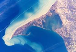
 Long Point Peninsula with bright sediment plumes. (The top of the image points southwest, rather than north.) Source: NASA | |
Location of Long Point in Ontario | |
| Coordinates: 42°32′51″N 80°3′33″W / 42.54750°N 80.05917°W | |
| Country | Canada |
| Province | Ontario |
| Amalgamated into Norfolk County | 2001 (Single-tier municipality) |
| Government | |
| • Mayor | Kristal Chopp |
| • Governing Body | The Council of The Corporation of Norfolk County |
| • MPs | Diane Finley (Con) |
| • MPPs | Bobbi Ann Brady (Independent) |
| Elevation | 210 m (690 ft) |
| Time zone | UTC-5 (EST) |
| • Summer (DST) | UTC-4 (EDT) |
| Forward sortation area | |
| Area code(s) | 519 and 226 |
| Website | www |
| Official name | Long Point |
| Designated | 24 May 1982 |
| Reference no. | 237[1] |
Long Point is a sand spit and medium-sized hamlet on the north shore of Lake Erie, part of Norfolk County in the province of Ontario, Canada.
It is about 40 kilometres (25 mi) long and is about 1 kilometre (0.62 mi) across at its widest point. Lake Erie lies to the south of Long Point, and Long Point Bay lies on the north side. The bay is subdivided into the Inner Bay and Outer Bay by a line that runs between Turkey Point to the north and Pottahawk Point to the south. Some of the towns along the bay's north shore include Port Rowan, Turkey Point and Port Dover. Long Point is north of and across the lake from Presque Isle and Erie, Pennsylvania.
- ^ "Long Point". Ramsar Sites Information Service. Retrieved 25 April 2018.
