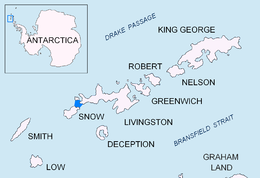
 Location of Morton Strait in the South Shetland Islands | |
 | |
| Geography | |
|---|---|
| Location | Antarctica |
| Coordinates | 62°42′S 61°11′W / 62.700°S 61.183°W |
| Archipelago | South Shetland Islands |
| Length | 0.72 km (0.447 mi) |
| Width | 0.18 km (0.112 mi) |
| Highest elevation | 13 m (43 ft) |
| Administration | |
| Administered under the Antarctic Treaty System | |
| Demographics | |
| Population | Uninhabited |


Long Rock is a large rock extending 720 m (787 yd) in east–west direction, 180 m (197 yd) wide and rising to 13 m (42.7 ft) in the northeast of Morton Strait in the South Shetland Islands, Antarctica. The area was visited by early 19th century sealers operating on Byers Peninsula.
The feature was named by Discovery Investigations personnel that charted Morton Strait in 1930–31.