Longjumeau | |
|---|---|
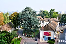
 Nativelle Park | |
 Location (in red) within Paris inner and outer suburbs | |
| Coordinates: 48°41′39″N 2°17′45″E / 48.6943°N 2.2958°E | |
| Country | France |
| Region | Île-de-France |
| Department | Essonne |
| Arrondissement | Palaiseau |
| Canton | Longjumeau |
| Intercommunality | CA Paris-Saclay |
| Government | |
| • Mayor (2020–2026) | Sandrine Gelot[1] (LR) |
Area 1 | 4.84 km2 (1.87 sq mi) |
| Population (2021)[2] | 20,620 |
| • Density | 4,300/km2 (11,000/sq mi) |
| Demonym | Longjumellois |
| Time zone | UTC+01:00 (CET) |
| • Summer (DST) | UTC+02:00 (CEST) |
| INSEE/Postal code | 91345 /91160 |
| Elevation | 40–93 m (131–305 ft) |
| Website | www.longjumeau.fr |
| 1 French Land Register data, which excludes lakes, ponds, glaciers > 1 km2 (0.386 sq mi or 247 acres) and river estuaries. | |
Longjumeau (French pronunciation: [lɔ̃ʒymo] ) is a commune in the Essonne department, France. It is located 18.2 km (11.3 mi) south from the center of Paris. Inhabitants of Longjumeau are known as Longjumellois (French pronunciation: [lɔ̃ʒymɛlwa]) in French.
- ^ "Répertoire national des élus: les maires" (in French). data.gouv.fr, Plateforme ouverte des données publiques françaises. 6 June 2023.
- ^ "Populations légales 2021" (in French). The National Institute of Statistics and Economic Studies. 28 December 2023.


