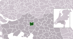
Loon op Zand | |
|---|---|
 Windmill in Kaatsheuvel | |
 Location in North Brabant | |
| Coordinates: 51°40′N 5°2′E / 51.667°N 5.033°E | |
| Country | Netherlands |
| Province | North Brabant |
| Government | |
| • Body | Municipal council |
| • Mayor | Hanne van Aart (VVD) |
| Area | |
| • Total | 50.71 km2 (19.58 sq mi) |
| • Land | 49.94 km2 (19.28 sq mi) |
| • Water | 0.77 km2 (0.30 sq mi) |
| Elevation | 5 m (16 ft) |
| Population (January 2021)[4] | |
| • Total | 23,504 |
| • Density | 471/km2 (1,220/sq mi) |
| Time zone | UTC+1 (CET) |
| • Summer (DST) | UTC+2 (CEST) |
| Postcode | 5170–5176 |
| Area code | 013, 0416 |
| Website | www |

Loon op Zand (Dutch pronunciation: [ˈloːn ɔp ˈsɑnt] )[a] is a municipality and a village in the southern Netherlands. It had a population of 23,504 in 2021.
The western part of national park the Loonse en Drunense Duinen is located in the municipality of Loon op Zand.
- ^ "Burgemeester dhr. W.C. Luijendijk" (in Dutch). Gemeente Loon op Zand. Archived from the original on 30 May 2014. Retrieved 29 May 2014.
- ^ "Kerncijfers wijken en buurten 2020" [Key figures for neighbourhoods 2020]. StatLine (in Dutch). CBS. 24 July 2020. Retrieved 19 September 2020.
- ^ "Postcodetool for 5171EJ". Actueel Hoogtebestand Nederland (in Dutch). Het Waterschapshuis. Archived from the original on 21 September 2013. Retrieved 29 May 2014.
- ^ "Bevolkingsontwikkeling; regio per maand" [Population growth; regions per month]. CBS Statline (in Dutch). CBS. 1 January 2021. Retrieved 2 January 2022.
Cite error: There are <ref group=lower-alpha> tags or {{efn}} templates on this page, but the references will not show without a {{reflist|group=lower-alpha}} template or {{notelist}} template (see the help page).

