Loosbroek | |
|---|---|
Village | |
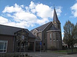
 Church of Loosbroek | |
| Coordinates: 51°41′0″N 5°30′0″E / 51.68333°N 5.50000°E | |
| Country | Netherlands |
| Province | North Brabant |
| Municipality | Bernheze |
| Area | |
| • Total | 0.55 km2 (0.21 sq mi) |
| Elevation | 8 m (26 ft) |
| Population (2021)[1] | |
| • Total | 1,015 |
| • Density | 1,800/km2 (4,800/sq mi) |
| Time zone | UTC+1 (CET) |
| • Summer (DST) | UTC+2 (CEST) |
| Postal code | 5472[1] |
| Dialing code | 0413 |
| Major roads | A50, N279 |
Loosbroek is a village and parish in the southern Netherlands. It is located in the municipality Bernheze, North Brabant.[3]
Before 1994 the territory of Loosbroek was divided between three municipalities, Nistelrode, Heesch and Heeswijk-Dinther.[4]
- ^ a b c "Kerncijfers wijken en buurten 2021". Central Bureau of Statistics. Retrieved 15 April 2022.
- ^ "Postcodetool for 5472LA". Actueel Hoogtebestand Nederland (in Dutch). Het Waterschapshuis. Retrieved 15 April 2022.
- ^ "Gemeente Bernheze" (in Dutch). Gemeente Bernheze. Retrieved 5 March 2011.
- ^ "Loosbroek". Plaatsengids (in Dutch). Retrieved 15 April 2022.

