| Río Los Esclavos | |
|---|---|
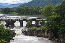
 Bridge over Los Esclavos river | |
| Location | |
| Country | Guatemala |
| Physical characteristics | |
| Source | |
| • location | Mataquescuintla (Santa Rosa) |
| • coordinates | 14°28′28″N 90°14′35″W / 14.47444°N 90.24306°W |
| • elevation | 2,000 m (6,600 ft) |
| Mouth | |
• location | Laguna de Sipacate |
• coordinates | 13°50′20″N 90°19′46″W / 13.83889°N 90.32944°W |
• elevation | 0 m (0 ft) |
| Length | 145 km (90 mi) |
| Basin size | Pacific |
| Discharge | |
| • average | 15.8 m3/s (560 cu ft/s) (La Sonrisa) |
The Río Los Esclavos is a river in southern Guatemala. Its sources are in the mountains in the southeast of the department of Santa Rosa. From there it flows past the town of Cuilapa through the coastal plains of Santa Rosa into the Laguna de Sipacate and then into the Pacific Ocean.[1]
The Los Esclavos river basin covers a territory of 2,271 km2 (877 sq ml).[2]
- ^ INSIVUMEH. "Mapa de Cuencas y Ríos".
- ^ INSIVUMEH. "Principales ríos de Guatemala".
