7°56′N 80°25′W / 7.933°N 80.417°W
Los Santos
Provincia de Los Santos | |
|---|---|
From top, left to right: view of San Atanasio church in Los Santos, view of downtown Las Tablas by the church of Santa Librada, Ateles geoffroyi azuerensis, Cerro del Canajagua, a beach in Pedasi, Casa Museo Manuel F. Zárate, Museo de la Nacionalidad in Los Santos, a natural landscape of Tonosi coast at Las Canas, Empollerada in Las Tablas. | |
 | |
| Country | Panama |
| Capital city | Las Tablas |
| Government | |
| • Governor | Rubén Villarreal |
| Area | |
• Total | 3,809.4 km2 (1,470.8 sq mi) |
| Population (2023 census)[1] | |
• Total | 98,466 |
| • Density | 26/km2 (67/sq mi) |
| Demonym | Santeño (a)[2] |
| GDP (PPP, constant 2015 values) | |
| • Year | 2023 |
| • Total | $2.4 billion[3] |
| • Per capita | $27,100 |
| Time zone | UTC-5 (Eastern Time) |
| ISO 3166 code | PA-7 |
| HDI (2017) | 0.813[4] Very high |
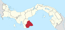
Los Santos (Spanish pronunciation: [los ˈsantos]) is a province in Panama, reaching from the La Villa river in the North to the Pacific Ocean in the south and east. It is part of the Azuero Peninsula, bounded by the province of Herrera to the north and northeast, and by Mariato District of Veraguas Province to the West. The City of Las Tablas is the capital and most populous city. There are seven administrative districts under the jurisdiction of Los Santos Province. Los Santos's area is 3,809.4 km ², and its population is 98,466 inhabitants in 2023.[1][5]
In this region are the oldest human settlements in the Isthmus of Panama. It was part of the cultural region of Gran Cocle where one of the first ceramic styles of the Americas developed.[6] The first Europeans to explore Los Santos were the Spanish in 1515 under the command of Gonzalo de Badajoz. Upon the arrival of Europeans the area was ruled by the cacique Antataura or Cutara, and was known as the Land of Mr. Paris or Parita from Ngäbere Bari-ta meaning Confederation of Peoples, having under his control six other Indigenous chiefdoms: Guararí, Quemá, Chiracoitia, Huere, Guanata and Usagaña. The only province that was not under his dominion was Escoria. Gaspar de Espinosa succeeded in conquering and annexing Pariba to the Spanish Empire in 1516, decimating nearly all of the native population.
Geographically, Los Santos is located in the 'Arco Seco', name given to the strip of land between the Gulf of Panama and the Central Mountain range which includes areas of the provinces of Coclé, Herrera and Veraguas in the south of the Isthmus of Panama.[7] Its climate is mainly a tropical savanna climate with moderate temperatures, strongly influenced by the winds of the Pacific Ocean crashing against the mountains, and the Humboldt Current. The average annual rainfall is 1,200 mm, allowing the growth of either dry or humid rainforest. Its highest point is located at the peak of Cerro Hoya with 1559 metres. Other major peaks are Cambutal hill (1400 metres) and Mount The Ñopos (1068 metres).
The modern province of Los Santos, was created in January 1945 replacing the defunct province of Azuero according to Cabinet Decree No. 13, leaving its territorial regime regulated by the second chapter of the Law 58 of July 29, 1998, losing the Territory of Quebro in this process.
Although Los Santos closely shares its political and social history with the rest of Panama, and the vast majority of the population speaks Spanish, the province has retained a distinct cultural identity. Los Santos' culture is the result of the passage of different peoples and civilizations that, over time, have shaped a particular cultural identity. These people, some very different from each other, have been slowly leaving an imprint seated among the inhabitants. It is one of the last regions in Panama where Spanish voseo is the standard form for use.
- ^ a b Instituto Nacional de Estadística y Censo, Ciudad de Panamá.
- ^ "Diccionario de la lengua española | Edición del Tricentenario".
- ^ "TelluBase—Panama Fact Sheet (Tellusant Public Service Series)" (PDF). Tellusant. Retrieved 2024-01-11.
- ^ "Sub-national HDI - Area Database - Global Data Lab". hdi.globaldatalab.org. Retrieved 2018-09-13.
- ^ "Los Santos (Province, Panama) - Population Statistics, Charts, Map and Location". www.citypopulation.de. Retrieved 2024-03-10.
- ^ http://biblioteca.ucm.es/tesis/ghi/ucm-t27302.pdf [bare URL PDF]
- ^ http://www.pnuma.org/deat1/pdf/GEOPanama2004.pdf [bare URL PDF]


