Loughtee Lower
Lucht Tí Íochtarach (Irish) | |
|---|---|
 Centre of Milltown, County Cavan | |
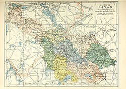
 Barony map of County Cavan, 1900; Loughtee Lower is in the north, coloured pale yellow. | |
| Sovereign state | Ireland |
| Province | Ulster |
| County | Cavan |
| Area | |
• Total | 114.28 km2 (44.13 sq mi) |
Loughtee Lower (Irish: Lucht Tí Íochtarach), or Lower Loughtee, is a barony in County Cavan, Ireland.[1][2][3] Baronies were mainly cadastral rather than administrative units.[4] They acquired modest local taxation and spending functions in the 19th century before being superseded by the Local Government (Ireland) Act 1898.[5]
- ^ "The Parliamentary Gazetteer of Ireland: Adapted to the New Poor-law, Franchise, Municipal and Ecclesiastical Arrangements, and Compiled with a Special Reference to the Lines of Railroad and Canal Communication, as Existing in 1814-45". A. Fullarton and Company. 5 March 1846 – via Google Books.
- ^ Commons, Great Britain Parliament House of (5 March 1876). "Accounts and Papers of the House of Commons". Ordered to be printed – via Google Books.
- ^ "Drumlane - Topographical Dictionary of Ireland (1837)". www.libraryireland.com.
- ^ "Griffith Lodge, ARTONAGH (LOWER LOUGHTEE BY.), CAVAN". Buildings of Ireland.
- ^ General Register Office of Ireland (1904). "Alphabetical index to the baronies of Ireland". Census of Ireland 1901: General topographical index. Command papers. Vol. Cd. 2071. HMSO. pp. 966–978.