 | |
 | |
| Location | Louisbourg, Nova Scotia |
|---|---|
| Coordinates | 45°54′24.1″N 59°57′30.5″W / 45.906694°N 59.958472°W |
| Tower | |
| Constructed | 1734 (first) 1738 (second) 1842 (third) |
| Construction | concrete tower |
| Automated | 1990 |
| Height | 16.8 m (55 ft) (current) 16.5 metres (54 ft) (first) 17 metres (56 ft) (second) |
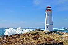
| Shape | octagonal tower with balcony and lantern |
| Markings | white tower, red lantern |
| Operator | Louisbourg Lighthouse Society[1] |
| Heritage | recognized federal heritage building of Canada |
| Light | |
| First lit | 1923 (current) |
| Deactivated | 1758-1842 |
| Focal height | 32 m (105 ft) |
| Range | 16 nautical miles (30 km; 18 mi) |
| Characteristic | Fl W 15s. |
Louisbourg Lighthouse is an active Canadian lighthouse in Louisbourg, Nova Scotia. The current tower is the fourth in a series of lighthouses that have been built on the site, the earliest was the first lighthouse in Canada.
- ^ Rowlett, Russ. "Lighthouses of Canada: Cape Breton Island, Nova Scotia". The Lighthouse Directory. University of North Carolina at Chapel Hill. Retrieved January 3, 2016.