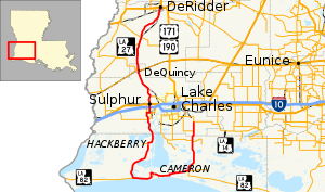
 Route of LA 27 highlighted in red | ||||
| Route information | ||||
| Maintained by Louisiana DOTD | ||||
| Length | 132.424 mi[1] (213.116 km) | |||
| Existed | 1955 renumbering–present | |||
| Tourist routes | ||||
| Major junctions | ||||
| Southeast end | ||||
| Northwest end | ||||
| Location | ||||
| Country | United States | |||
| State | Louisiana | |||
| Parishes | Calcasieu, Cameron, Beauregard | |||
| Highway system | ||||
| ||||
| ||||
Louisiana Highway 27 (LA 27) is a state highway located in southwestern Louisiana. It runs 132.42 miles (213.11 km) in a general north–south direction from LA 14 in Holmwood to the junction of U.S. Highways 171 and 190 in DeRidder.
The route travels in a mirror-image of the letter "J" as it loops through the wetlands surrounding Calcasieu Lake and passes through Cameron, a small community situated on the Gulf of Mexico. It then extends northward through Sulphur en route to its terminus in DeRidder.
LA 27 essentially functions as two north–south roadways connecting the sparsely populated Cameron Parish to the Lake Charles metropolitan area and is signed accordingly. The north–south directional banners are reversed at the Cameron Ferry, a toll ferry the crosses the Calcasieu Ship Channel.
- ^ Louisiana Department of Transportation and Development, Highway Inventory Unit (2016). "LRS Conversion Tool". Louisiana Department of Transportation and Development. Retrieved February 26, 2018.
