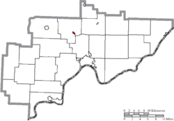
Lowell, Ohio | |
|---|---|
 Fourth Street | |
 Location of Lowell, Ohio | |
 Location of Lowell in Washington County | |
| Coordinates: 39°31′45″N 81°30′25″W / 39.52917°N 81.50694°W | |
| Country | United States |
| State | Ohio |
| County | Washington |
| Government | |
| • Type | Mayor-council |
| • Mayor | Steve Weber[1] |
| Area | |
| • Total | 0.24 sq mi (0.61 km2) |
| • Land | 0.23 sq mi (0.59 km2) |
| • Water | 0.01 sq mi (0.02 km2) |
| Elevation | 623 ft (190 m) |
| Population (2020) | |
| • Total | 567 |
| • Density | 2,478.07/sq mi (957.41/km2) |
| Time zone | UTC-5 (Eastern (EST)) |
| • Summer (DST) | UTC-4 (EDT) |
| ZIP code | 45744 |
| Area code | 740 |
| FIPS code | 39-45164[4] |
| GNIS feature ID | 2399194[3] |
Lowell is a village in Washington County, Ohio, United States, along the Muskingum River. The population was 549 at the 2020 census. The village is located about 7.6 miles (12.2 km) north of Marietta, Ohio.
- ^ "Washington County Public Officials". Retrieved March 18, 2008.
- ^ "ArcGIS REST Services Directory". United States Census Bureau. Retrieved September 20, 2022.
- ^ a b U.S. Geological Survey Geographic Names Information System: Lowell, Ohio
- ^ "U.S. Census website". United States Census Bureau. Retrieved January 31, 2008.