This article needs additional citations for verification. (February 2020) |


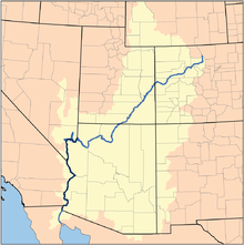
The Lower Colorado River Valley (LCRV) is the river region of the lower Colorado River of the southwestern United States in North America that rises in the Rocky Mountains and has its outlet at the Colorado River Delta in the northern Gulf of California in northwestern Mexico, between the states of Baja California and Sonora. This north–south stretch of the Colorado River forms the border between the U.S. states of California/Arizona and Nevada/Arizona,[1] and between the Mexican states of Baja California/Sonora.
It is commonly defined as the region from below Hoover Dam and Lake Mead to its outlet at the northern Gulf of California (Sea of Cortez); it includes the Colorado River proper, canyons, the valley, mountain ranges with wilderness areas, and the floodplain and associated riparian environments. It is home to recreation activities from the river, the lakes created by dams, agriculture, and the home of various cities, communities, and towns along the river, or associated with the valley region. Five Indian reservations are located in the LCRV: the Chemehuevi, Fort Mojave and Colorado River Indian Reservations; at Yuma are the Quechan and Cocopah reservations.