This article has multiple issues. Please help improve it or discuss these issues on the talk page. (Learn how and when to remove these messages)
|
| Lower Saxon Wadden Sea National Park | |
|---|---|
| Nationalpark Niedersächsisches Wattenmeer | |
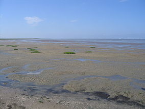
 The Pilsumer Watt from the Leyhörn peninsula, East Frisia | |
 Germany | |
| Location | Lower Saxony, |
| Coordinates | 53°42′N 7°20′E / 53.700°N 7.333°E |
| Area | 345.8 km2 (133.5 sq mi) |
| Established | January 1, 1986 |
| World Heritage site | 2009 |
| Official name | Wattenmeer, Ostfriesisches Wattenmeer & Dollart |
| Designated | 26 February 1976 |
| Reference no. | 82[1] |
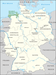
The Lower Saxon Wadden Sea National Park (German: Nationalpark Niedersächsisches Wattenmeer) was established in 1986 and embraces the East Frisian Islands, mudflats and salt marshes between the Bay of Dollart on the border with the Netherlands in the west and Cuxhaven as far as the Outer Elbe shipping channel in the east. The national park has an area of about 345,800 hectares (1,335 sq mi).[2] The National Park organisation is located in Wilhelmshaven. In June 2009, the National Park became a UNESCO World Heritage Site along with the Schleswig-Holstein Wadden Sea and the Dutch Wadden Sea, highlighting its unique intertidal ecosystem and high biodiversity.[3]
- ^ "Schleswig-Holstein Wadden Sea and adjacent areas". Ramsar Sites Information Service. Retrieved 25 April 2018.
- ^ "Nationalpark Wattenmeer". Zahlen & Daten. Archived from the original on 2010-05-27. Retrieved 1 July 2010.
- ^ "Wadden Sea". UNESCO World Heritage Centre. United Nations Educational, Scientific, and Cultural Organization. Retrieved 20 Jun 2021.