Lower Towamensing Township | |
|---|---|
 Little Gap Covered Bridge, February 1971 | |
 Location of Lower Towamensing Township in Carbon County, Pennsylvania | |
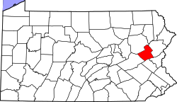
 Location of Carbon County in Pennsylvania | |
| Coordinates: 40°48′00″N 75°37′31″W / 40.80000°N 75.62528°W | |
| Country | United States |
| State | Pennsylvania |
| County | Carbon |
| Area | |
• Total | 21.30 sq mi (55.17 km2) |
| • Land | 21.25 sq mi (55.05 km2) |
| • Water | 0.04 sq mi (0.12 km2) |
| Elevation | 449 ft (137 m) |
| Population (2010) | |
• Total | 3,228 |
• Estimate (2016)[2] | 3,168 |
| • Density | 149.05/sq mi (57.55/km2) |
| Time zone | UTC-5 (EST) |
| • Summer (DST) | UTC-4 (EDT) |
| Area code | 610 |
| FIPS code | 42-025-45128 |
| Website | www |
Lower Towamensing Township is a township in Carbon County, Pennsylvania. It is part of Northeastern Pennsylvania. The Lenape Indian tribe name is eponymous and was once applied by the natives to the whole region[3] of Carbon County and bits of the Poconos to the north (Luzerne County) and to Schuylkill County (southwest). The population was 3,228 at the 2010 census.[4]
- ^ "2016 U.S. Gazetteer Files". United States Census Bureau. Retrieved Aug 13, 2017.
- ^ "Population and Housing Unit Estimates". Retrieved June 9, 2017.
- ^
Fred Brenckman (1913). "Chapter V. Captivity of the Gilbert Family". History of Carbon County Pennsylvania. Harrisburg, PA: Publisher: James J. Nungesser ('gutenberg project' e-reprint). p. 62.
... before the ring of the axe was again heard in the forests, and the curling smoke wreaths ascended from the chimneys of the log cabins of Towamensing, as this whole region was then known.
- ^ "Geographic Identifiers: 2010 Census Summary File 1 (G001): Lower Towamensing township, Carbon County, Pennsylvania". U.S. Census Bureau, American Factfinder. Archived from the original on April 6, 2015. Retrieved April 6, 2015.