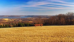
Lower Windsor Township, Pennsylvania | |
|---|---|
 Samuel S. Lewis State Park | |
 Location in York County and the state of Pennsylvania. | |
| Country | United States |
| State | Pennsylvania |
| County | York |
| Settled | 1722 |
| Incorporated | 1838 |
| Government | |
| • Type | Board of Supervisors |
| Area | |
• Total | 25.02 sq mi (64.79 km2) |
| • Land | 25.02 sq mi (64.79 km2) |
| • Water | 0.00 sq mi (0.00 km2) |
| Population | |
• Total | 7,511 |
• Estimate (2021)[2] | 7,534 |
| • Density | 299.12/sq mi (115.49/km2) |
| Time zone | UTC-5 (Eastern (EST)) |
| • Summer (DST) | UTC-4 (EDT) |
| Area code | 717 |
| FIPS code | 42-133-45152 |
| Census | Pop. | Note | %± |
|---|---|---|---|
| 1850 | 1,923 | — | |
| 1860 | 2,162 | 12.4% | |
| 1870 | 2,429 | 12.3% | |
| 1880 | 2,538 | 4.5% | |
| 1890 | 2,764 | 8.9% | |
| 1900 | 2,649 | −4.2% | |
| 1910 | 2,607 | −1.6% | |
| 1920 | 2,053 | −21.3% | |
| 1930 | 2,209 | 7.6% | |
| 1940 | 2,724 | 23.3% | |
| 1950 | 2,934 | 7.7% | |
| 1960 | 3,424 | 16.7% | |
| 1970 | 3,879 | 13.3% | |
| 1980 | 5,977 | 54.1% | |
| 1990 | 7,051 | 18.0% | |
| 2000 | 7,405 | 5.0% | |
| 2010 | 7,382 | −0.3% | |
| 2020 | 7,511 | 1.7% | |
| 2021 (est.) | 7,534 | [2] | 0.3% |
| U.S. Decennial Census[3] | |||
Lower Windsor Township is a township in York County, Pennsylvania, United States. The population was 7,511 at the 2020 census.[2] Samuel S. Lewis State Park overlooks the Susquehanna River in the eastern part of the township.
- ^ "2016 U.S. Gazetteer Files". United States Census Bureau. Retrieved August 14, 2017.
- ^ a b c d Bureau, US Census. "City and Town Population Totals: 2020-2021". Census.gov. US Census Bureau. Retrieved July 8, 2022.
{{cite web}}:|last1=has generic name (help) - ^ "Census of Population and Housing". Census.gov. Retrieved June 4, 2016.