| Lowestoft | |
|---|---|
| Town and civil parish | |
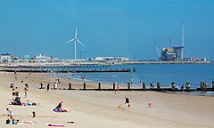
 Lowestoft beach and outer harbour | |
Location within Suffolk | |
| Area | 21.43 km2 (8.27 sq mi) |
| Population | 71,327 (2021 census)[a] |
| • Density | 3,328/km2 (8,620/sq mi) |
| OS grid reference | TM548933 |
| • London | 110 mi (180 km) south-west |
| Civil parish |
|
| District | |
| Shire county | |
| Region | |
| Country | England |
| Sovereign state | United Kingdom |
| Areas of the town | List |
| Post town | Lowestoft |
| Postcode district | NR32, NR33 |
| Dialling code | 01502 |
| Police | Suffolk |
| Fire | Suffolk |
| Ambulance | East of England |
| UK Parliament | |
| Website | Lowestoft Town Council |
Lowestoft (/ˈloʊ(ɪ)stɒft, ˈloʊstəf/ LOH-(ih)-stoft, LOH-stəf) is a coastal town and civil parish in the East Suffolk district of Suffolk, England.[1] As the most easterly UK settlement, it is 38 miles (61 km) north-east of Ipswich and 22 miles (35 km) south-east of Norwich, and the main town in its district. Its development grew with the fishing industry and as a seaside resort with wide sandy beaches. As fishing declined, oil and gas exploitation in the North Sea in the 1960s took over. In 2021 the built-up area had a population of 71,327[2] and the parish had a population of 47,879.[3]
Cite error: There are <ref group=lower-alpha> tags or {{efn}} templates on this page, but the references will not show without a {{reflist|group=lower-alpha}} template or {{notelist}} template (see the help page).
- ^ OS Explorer Map OL40: The Broads: (1:25 000) : ISBN 0 319 24086 X.
- ^ "Lowestoft". City Population. Retrieved 10 August 2024.
- ^ "Lowestoft". City Population. Retrieved 10 August 2024.
