Lubang | |
|---|---|
| Municipality of Lubang | |
 Cabra Island Lighthouse | |
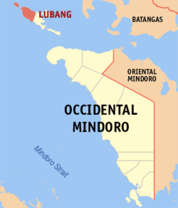
 Map of Occidental Mindoro with Lubang highlighted | |
Location within the Philippines | |
| Coordinates: 13°51′31″N 120°07′22″E / 13.8586°N 120.1228°E | |
| Country | Philippines |
| Region | Mimaropa |
| Province | Occidental Mindoro |
| District | Lone district |
| Barangays | 16 (see Barangays) |
| Government | |
| • Type | Sangguniang Bayan |
| • Mayor | Michael L. Orayani |
| • Vice Mayor | Charles Z. Villas |
| • Representative | Leody “Odie” F. Tarriela |
| • Municipal Council | Members |
| • Electorate | 13,799 voters (2022) |
| Area | |
• Total | 113.10 km2 (43.67 sq mi) |
| Elevation | 9.0 m (29.5 ft) |
| Highest elevation | 125 m (410 ft) |
| Lowest elevation | 0 m (0 ft) |
| Population (2020 census)[3] | |
• Total | 17,437 |
| • Density | 150/km2 (400/sq mi) |
| • Households | 4,680 |
| Economy | |
| • Income class | 4th municipal income class |
| • Poverty incidence | 22.25 |
| • Revenue | ₱ 125 million (2020) |
| • Assets | ₱ 353.4 million (2020) |
| • Expenditure | ₱ 140.8 million (2020) |
| • Liabilities | ₱ 60.99 million (2020) |
| Service provider | |
| • Electricity | Lubang Electric Cooperative (LUBELCO) |
| Time zone | UTC+8 (PST) |
| ZIP code | 5109 |
| PSGC | |
| IDD : area code | +63 (0)43 |
| Native languages | Tagalog |
Lubang, officially the Municipality of Lubang (Tagalog: Bayan ng Lubang), is a 4th class municipality in the province of Occidental Mindoro, Philippines. According to the 2020 census, it has a population of 17,437 people.[3]
The municipality encompasses the north-western half of Lubang Island, as well as Cabra Island, which are part of the Tagalog homeland. The municipality of Lubang is part of the Lubang Island Group, which constitutes seven islands that are geographically distinct from any landmasses, making the island group biologically unique - and endangered at the same time. The islands are under consideration to be set as a UNESCO tentative site due to its geographic importance, biological diversity, and intact rainforests.[5]
- ^ Municipality of Lubang | (DILG)
- ^ "2015 Census of Population, Report No. 3 – Population, Land Area, and Population Density" (PDF). Philippine Statistics Authority. Quezon City, Philippines. August 2016. ISSN 0117-1453. Archived (PDF) from the original on May 25, 2021. Retrieved July 16, 2021.
- ^ a b Census of Population (2020). "Mimaropa". Total Population by Province, City, Municipality and Barangay. Philippine Statistics Authority. Retrieved 8 July 2021.
- ^ "PSA Releases the 2021 City and Municipal Level Poverty Estimates". Philippine Statistics Authority. 2 April 2024. Retrieved 28 April 2024.
- ^ Groves, Colin P. (1997). "Taxonomy of wild pigs (Sus) of the Philippines". Zoological Journal of the Linnean Society. 120 (2): 163–191. doi:10.1111/j.1096-3642.1997.tb01277.x.


