This article needs additional citations for verification. (October 2017) |
Lubango
Sá da Bandeira | |
|---|---|
| Coordinates: 14°55′S 13°30′E / 14.917°S 13.500°E | |
| Country | Angola |
| Province | Huíla |
| Area | |
| • Total | 360.0 km2 (139.0 sq mi) |
| Elevation | 1,720 m (5,640 ft) |
| Population (2014 Census)[1] | |
| • Total | 776,246 |
| • Density | 2,200/km2 (5,600/sq mi) |
| Time zone | UTC+1 (WAT) |
| Climate | Cwb |
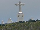
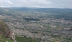
Lubango, formerly known as Sá da Bandeira, is a municipality in Angola, capital of the Huíla Province, with a population of 914,456 in 2022.[2] The city center had a population of 600,751 in 2014[3] making it the second-most populous city in Angola after the capital city Luanda.
- ^ "Resultados Definitivos Recenseamento Geral da População e Habitação – 2014 Província da Huíla" (PDF). Instituto Nacional de Estatística, República de Angola. Retrieved 3 May 2020.
- ^ "Lubango Population 2022". worldpopulationreview. Retrieved 13 September 2022.
- ^ Citypopulation.de Population of the major cities in Angola


