This article needs additional citations for verification. (April 2012) |
Lucan
Leamhcán (Irish) | |
|---|---|
Town | |
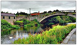
 The R109 road crosses the River Liffey at Coldblow Bridge, Lucan | |
| Coordinates: 53°21′16″N 6°26′55″W / 53.3544°N 6.4486°W | |
| Country | Ireland |
| Province | Leinster |
| County | County Dublin |
| Local government areas |
|
| Dáil constituency | Dublin Mid-West |
| EP constituency | Dublin |
| Population | |
| • Urban | 57,550 |
| Time zone | UTC+0 (WET) |
| • Summer (DST) | UTC+1 (IST (WEST)) |
| Irish Grid Reference | O029352 |
| Website | www |
Lucan (/ˈljuːkən/ LEW-kən; Irish: Leamhcán) is a southwestern outer suburb of Dublin, Ireland, located 12 km west of Dublin city centre, on the River Liffey. It is near the Strawberry Beds and Lucan Weir, and at the confluence of the River Griffeen. It is mostly in the local government area of South Dublin, with the exception of the North Lucan areas of Laraghcon, Coldblow and Saint Catherine's Park, which are in Fingal. Road access to Lucan is from the N4, and the M50 motorway at Junction 7.
- ^ "Census 2022 - F1008 Population by Electoral Divisions in County Dublin, by Birthplace". Central Statistics Office Census 2022 Reports. Central Statistics Office Ireland. August 2023. Retrieved 9 September 2023.

