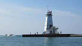
 Ludington Light in August 2023 | |
 | |
| Location | Ludington, Michigan |
|---|---|
| Coordinates | 43°57′13.002″N 86°28′9.737″W / 43.95361167°N 86.46937139°W |
| Tower | |
| Constructed | 1871 |
| Foundation | Pier |
| Construction | Steel / Reinforced concrete |
| Automated | 1972 |
| Height | 57 feet (17 m) |
| Shape | Square Pyramidal |
| Markings | white with black lantern |
| Heritage | National Register of Historic Places listed place |
| Fog signal | HORN: 2 blasts ev 30s (2s bl-2s si-2s bl-24s si). Operates from Apr. 1 to Oct. 1.[1] |
| Light | |
| First lit | 1871 |
| Deactivated | N/A |
| Focal height | 55 feet (17 m) |
| Lens | fifth order Fresnel Lens (original), 12-inch (300 mm) Tideland Signal ML-300 Acrylic Optic (current) |
| Intensity | 5000 candles |
| Range | 5 nautical miles (9.3 km; 5.8 mi) |
| Characteristic | Iso G 6s 55 |
Ludington North Breakwater Light | |
 | |
| Location | Ludington, Michigan |
| Built | 1924 |
| NRHP reference No. | 05000982[2] |
| Added to NRHP | September 6, 2005 |
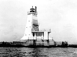
The Ludington Light is a 57-foot (17 m) tall steel-plated lighthouse in Ludington, Michigan, which lies along the eastern shores of Lake Michigan, at the end of the breakwater on the Pere Marquette Harbor. Given its location on the northern breakwater where the Pere Marquette River meets Lake Michigan, it is sometimes known as the Ludington North Breakwater Light. Underlying the building itself is a prow-like structure, which is designed to break waves.
- ^ Light List, Volume VII, Great Lakes (PDF). Light List. United States Coast Guard.
- ^ "National Register Information System". National Register of Historic Places. National Park Service. 2009-03-13. Archived from the original on 2008-07-25. Retrieved 2010-08-03.