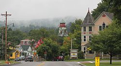
Ludlow, Vermont | |
|---|---|
 Ludlow downtown | |
 Location in Windsor County and the state of Vermont. | |
| Coordinates: 43°23′45″N 72°42′2″W / 43.39583°N 72.70056°W | |
| Country | United States |
| State | Vermont |
| County | Windsor |
| Communities |
|
| Area | |
• Total | 35.7 sq mi (92.5 km2) |
| • Land | 35.2 sq mi (91.1 km2) |
| • Water | 0.5 sq mi (1.4 km2) |
| Elevation | 1,067 ft (325 m) |
| Population (2020) | |
• Total | 2,172 |
| • Density | 61/sq mi (23/km2) |
| Time zone | UTC-5 (Eastern (EST)) |
| • Summer (DST) | UTC-4 (EDT) |
| ZIP code | 05149 |
| Area code | 802 |
| FIPS code | 50-41275[1] |
| GNIS feature ID | 1462138[2] |
| Website | www |
Ludlow is a town in Windsor County, Vermont, United States. The population was 2,172 at the 2020 census.[3] Ludlow is the home of Okemo Mountain, a popular ski resort. Before becoming a ski destination, Ludlow was originally a mill town, and was the home of a General Electric plant until 1977. It was arguably the most impacted by the flooding and natural disaster which ravaged Vermont in July 2023. The town of Ludlow was named after Ludlow, Massachusetts which is less than 100 miles away. There is also, where the town started, a village of Ludlow located in the town.
- ^ "U.S. Census website". United States Census Bureau. Retrieved January 31, 2008.
- ^ "US Board on Geographic Names". United States Geological Survey. October 25, 2007. Retrieved January 31, 2008.
- ^ "Census - Geography Profile: Ludlow town, Windsor County, Vermont". United States Census Bureau. Retrieved December 31, 2021.
