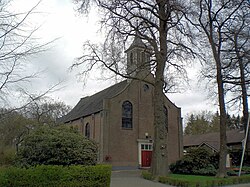
Lutten | |
|---|---|
 Dutch Reformed church | |
Location in province of Overijssel in the Netherlands | |
| Coordinates: 52°36′42″N 6°34′29″E / 52.6116°N 6.5747°E | |
| Country | Netherlands |
| Province | Overijssel |
| Municipality | Hardenberg |
| Area | |
| • Total | 12.18 km2 (4.70 sq mi) |
| Elevation | 8 m (26 ft) |
| Population (2021)[1] | |
| • Total | 2,045 |
| • Density | 170/km2 (430/sq mi) |
| Time zone | UTC+1 (CET) |
| • Summer (DST) | UTC+2 (CEST) |
| Postal code | 7775[1] |
| Dialing code | 0523 |
Lutten (Dutch Low Saxon: Luttn) is a village in the Dutch province of Overijssel. It is located in the municipality Hardenberg, about 13 kilometres (8.1 mi) south-west of Coevorden.[3]
- ^ a b c "Kerncijfers wijken en buurten 2021". Central Bureau of Statistics. Archived from the original on 22 December 2021. Retrieved 29 April 2022.
- ^ "Postcodetool for 7775AA". Actueel Hoogtebestand Nederland (in Dutch). Het Waterschapshuis. Archived from the original on 25 December 2018. Retrieved 29 April 2022.
- ^ "Distance Lutten, NLD -> Coevorden, NLD". Distance (in Dutch). Retrieved 29 April 2022.

