Luzhsky District
Лужский район | |
|---|---|
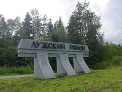
 Welcome sign at the entrance to Luzhsky District | |
 Location of Luzhsky District in Leningrad Oblast | |
| Coordinates: 58°44′N 29°51′E / 58.733°N 29.850°E | |
| Country | Russia |
| Federal subject | Leningrad Oblast[1] |
| Established | 1 August 1927 |
| Administrative center | Luga[1] |
| Area | |
• Total | 6,006.44 km2 (2,319.10 sq mi) |
| Population | |
• Total | 40,166 |
| • Density | 6.7/km2 (17/sq mi) |
| • Urban | 8.0% |
| • Rural | 92.0% |
| Administrative structure | |
| • Administrative divisions | 13 settlement municipal formation |
| • Inhabited localities[1] | 1 cities/towns, 1 Urban-type settlements[4], 346 rural localities |
| Municipal structure | |
| • Municipally incorporated as | Luzhsky Municipal District[5] |
| • Municipal divisions[5] | 2 urban settlements, 13 rural settlements |
| Time zone | UTC+3 (MSK |
| OKTMO ID | 41633000 |
| Website | luga |
Luzhsky District (Russian: Лу́жский райо́н) is an administrative[1] and municipal[5] district (raion), one of the seventeen in Leningrad Oblast, Russia. It is located in the southwest of the oblast and borders with Gatchinsky District in the north, Tosnensky District in the northeast, Novgorodsky and Batetsky Districts of Novgorod Oblast in the southeast, Shimsky District, also of Novgorod Oblast, in the south, Plyussky District of Pskov Oblast in the southwest, Slantsevsky District in the west, and Volosovsky District in the northwest. The area of the district is 6,006.44 square kilometers (2,319.10 sq mi).[2] Its administrative center is the town of Luga.[1] Population (excluding the administrative center): 40,166 (2010 Census);[3] 41,885 (2002 Census);[7] 48,721 (1989 Soviet census).[8]
- ^ a b c d e Oblast Law #32-oz
- ^ a b Official website of Luzhsky District. Socio-Economic Description (in Russian)
- ^ a b Russian Federal State Statistics Service (2011). Всероссийская перепись населения 2010 года. Том 1 [2010 All-Russian Population Census, vol. 1]. Всероссийская перепись населения 2010 года [2010 All-Russia Population Census] (in Russian). Federal State Statistics Service.
- ^ The count of urban-type settlements may include the work settlements, the resort settlements, the suburban (dacha) settlements, as well as urban-type settlements proper.
- ^ a b c Law #65-oz
- ^ "Об исчислении времени". Официальный интернет-портал правовой информации (in Russian). June 3, 2011. Retrieved January 19, 2019.
- ^ Federal State Statistics Service (May 21, 2004). Численность населения России, субъектов Российской Федерации в составе федеральных округов, районов, городских поселений, сельских населённых пунктов – районных центров и сельских населённых пунктов с населением 3 тысячи и более человек [Population of Russia, Its Federal Districts, Federal Subjects, Districts, Urban Localities, Rural Localities—Administrative Centers, and Rural Localities with Population of Over 3,000] (XLS). Всероссийская перепись населения 2002 года [All-Russia Population Census of 2002] (in Russian).
- ^ Всесоюзная перепись населения 1989 г. Численность наличного населения союзных и автономных республик, автономных областей и округов, краёв, областей, районов, городских поселений и сёл-райцентров [All Union Population Census of 1989: Present Population of Union and Autonomous Republics, Autonomous Oblasts and Okrugs, Krais, Oblasts, Districts, Urban Settlements, and Villages Serving as District Administrative Centers]. Всесоюзная перепись населения 1989 года [All-Union Population Census of 1989] (in Russian). Институт демографии Национального исследовательского университета: Высшая школа экономики [Institute of Demography at the National Research University: Higher School of Economics]. 1989 – via Demoscope Weekly.

