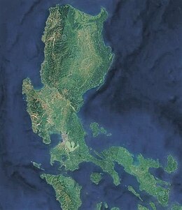
 Luzon satellite image captured by Sentinel-2 in 2016 | |
 | |
| Geography | |
|---|---|
| Location | Southeast Asia |
| Coordinates | 16°N 121°E / 16°N 121°E |
| Archipelago | Philippines |
| Adjacent to | |
| Major islands | |
| Area | 109,965 km2 (42,458 sq mi)[1] |
| Area rank | 15th |
| Coastline | 3,249.6 km (2019.21 mi)[1] |
| Highest elevation | 2,928 m (9606 ft) |
| Highest point | Mount Pulag |
| Administration | |
Philippines | |
| Regions | |
| Provinces | List
|
| Largest settlement | Quezon City (pop. 2,960,048 [2]) |
| Demographics | |
| Demonym | Luzonian (modern) Luzonense (occasional) Luções/Luzones (archaic) |
| Population | 64,260,312 (2021) (estimate) |
| Pop. density | 490/km2 (1270/sq mi) |
| Ethnic groups | |
Luzon (/luːˈzɒn/ loo-ZON, Tagalog: [luˈson]) is the largest and most populous island in the Philippines. Located in the northern portion of the Philippine archipelago, it is the economic and political center of the nation, being home to the country's capital city, Manila, as well as Quezon City, the country's most populous city. With a population of 64 million as of 2021[update],[3] it contains 52.5% of the country's total population and is the 4th most populous island in the world.[4] It is the 15th largest island in the world by land area.
Luzon may also refer to one of the three primary island groups in the country. In this usage, it includes the Luzon Mainland, the Batanes and Babuyan groups of islands to the north, Polillo Islands to the east, and the outlying islands of Catanduanes, Marinduque and Mindoro, among others, to the south.[5] The islands of Masbate, Palawan and Romblon are also included, although these three are sometimes grouped with another of the island groups, the Visayas.
- ^ a b Cite error: The named reference
unepwas invoked but never defined (see the help page). - ^ Census of Population (2020). Table B - Population and Annual Growth Rates by Province, City, and Municipality - By Region. Philippine Statistics Authority. Retrieved July 8, 2021.
- ^ Census of Population (2015). Highlights of the Philippine Population 2015 Census of Population. Philippine Statistics Authority. Retrieved June 20, 2016.
- ^ Boquet, Yves (2017). The Philippine Archipelago. Springer. p. 16. ISBN 9783319519265. Archived from the original on March 26, 2023. Retrieved December 22, 2018.
- ^ Zaide, Sonia M. The Philippines, a Unique Nation. p. 50.