Lycoming County | |
|---|---|
 The Lycoming County courthouse in Williamsport | |
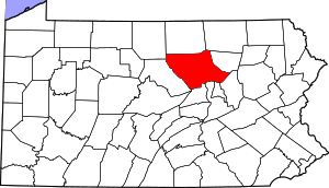
 Location within the U.S. state of Pennsylvania | |
 Pennsylvania's location within the U.S. | |
| Coordinates: 41°21′N 77°04′W / 41.35°N 77.06°W | |
| Country | |
| State | |
| Founded | April 13, 1795 |
| Named for | Lycoming Creek |
| Seat | Williamsport |
| Largest city | Williamsport |
| Area | |
• Total | 1,244 sq mi (3,220 km2) |
| • Land | 1,229 sq mi (3,180 km2) |
| • Water | 15 sq mi (40 km2) 1.2% |
| Population (2020) | |
• Total | 114,188 |
| • Density | 93/sq mi (36/km2) |
| Time zone | UTC−5 (Eastern) |
| • Summer (DST) | UTC−4 (EDT) |
| Congressional districts | 9th, 15th |
| Website | www |
Lycoming County is a county in the Commonwealth of Pennsylvania. As of the 2020 census, the population was 114,188.[1] Its county seat is Williamsport.[2] The county is part of the Central Pennsylvania region of the state.[a]
Lycoming County comprises the Williamsport metropolitan statistical area.
About 130 miles (210 km) northwest of Philadelphia and 165 miles (270 km) east-northeast of Pittsburgh, Lycoming is Pennsylvania's largest county by land area.
- ^ "Census - Geography Profile: Lycoming County, Pennsylvania". United States Census Bureau. Retrieved December 18, 2022.
- ^ "Find a County". National Association of Counties. Retrieved June 7, 2011.
Cite error: There are <ref group=lower-alpha> tags or {{efn}} templates on this page, but the references will not show without a {{reflist|group=lower-alpha}} template or {{notelist}} template (see the help page).

