Lyme, New Hampshire | |
|---|---|
Town | |
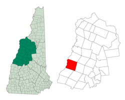
 Location in Grafton County, New Hampshire | |
| Coordinates: 43°48′37″N 72°09′22″W / 43.81028°N 72.15611°W | |
| Country | United States |
| State | New Hampshire |
| County | Grafton |
| Incorporated | 1761 |
| Villages | Lyme Lyme Center |
| Government | |
| • Select Board |
|
| • Town Administrator | Dina Cutting |
| Area | |
• Total | 55.0 sq mi (142.5 km2) |
| • Land | 53.8 sq mi (139.4 km2) |
| • Water | 1.2 sq mi (3.1 km2) 2.19% |
| Elevation | 548 ft (167 m) |
| Population (2020)[2] | |
• Total | 1,745 |
| • Density | 32/sq mi (12.5/km2) |
| Time zone | UTC-5 (Eastern) |
| • Summer (DST) | UTC-4 (Eastern) |
| ZIP Codes | 03768 (Lyme) 03769 (Lyme Center) |
| Area code | 603 |
| FIPS code | 33-44260 |
| GNIS feature ID | 0873654 |
| Website | www |
Lyme is a town along the Connecticut River in Grafton County, New Hampshire, United States. The population was 1,745 as of the 2020 census.[2] Lyme is home to the Chaffee Natural Conservation Area. The Dartmouth Skiway is in the eastern part of town, near the village of Lyme Center. The Appalachian Trail passes through the town's heavily wooded eastern end.
- ^ "2021 U.S. Gazetteer Files – New Hampshire". United States Census Bureau. Retrieved November 29, 2021.
- ^ a b "Lyme town, Grafton County, New Hampshire: 2020 DEC Redistricting Data (PL 94-171)". U.S. Census Bureau. Retrieved November 29, 2021.