Lytton | |
|---|---|
Village | |
| The Corporation of the Village of Lytton[1] | |
 Lytton in 2011 | |
Location of Lytton in British Columbia | |
| Coordinates: 50°13′52″N 121°34′53″W / 50.23111°N 121.58139°W | |
| Country | Canada |
| Province | British Columbia |
| Regional district | Thompson–Nicola |
| Incorporated | 1945 |
| Government | |
| • Governing body | Lytton Village Council |
| • Mayor | Denise O'Connor |
| Area | |
• Total | 6.54 km2 (2.53 sq mi) |
| Elevation | 195 m (640 ft) |
| Population (2021) | |
• Total | 210 |
| Time zone | UTC−08:00 (PST) |
| • Summer (DST) | UTC−07:00 (PDT) |
| Website | lytton.ca |
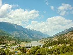
Lytton is a village of about 250 residents in southern British Columbia, Canada, on the east side of the Fraser River and primarily the south side of the Thompson River, where it flows southwesterly into the Fraser. The community includes the Village of Lytton and the surrounding community of the Lytton First Nation, whose name for the place is Camchin, also spelled Kumsheen ("river meeting").
During heat waves, Lytton is often the hottest spot in Canada despite its location north of 50°N in latitude. In three consecutive days of June 2021, it broke the all-time record for Canada's highest temperature, ending at 49.6 °C (121.3 °F) on June 29. This is the highest temperature ever recorded north of 45°N and higher than the all-time records for Europe and South America. The next day (June 30), a wildfire swept through the valley, destroying the majority of the town.

The Lytton area has been inhabited by the First Nations people for over 10,000 years.[2][3] It was one of the earliest locations settled by immigrants in the Southern Interior of British Columbia. The town was founded during the Fraser Canyon Gold Rush of 1858–59, when it was known as "The Forks."
- ^ "British Columbia Regional Districts, Municipalities, Corporate Name, Date of Incorporation and Postal Address" (XLS). British Columbia Ministry of Communities, Sport and Cultural Development. Archived from the original on July 13, 2014. Retrieved November 2, 2014.
- ^ "About Lytton". Village of Lytton. July 1, 2021. Archived from the original on July 9, 2021. Retrieved July 1, 2021.
- ^ Lytton was built on Kumsheen, and now the town is gone. In rebuilding, Nlaka’pamux people see an opportunity for reclamation Alex MMcKeen, The Star. July 17, 2021

