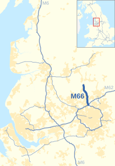
| M66 | ||||
|---|---|---|---|---|
 Looking northwest up the M66 at Junction 1 | ||||
| Route information | ||||
| Maintained by National Highways | ||||
| Length | 8.0 mi (12.9 km) | |||
| Existed | 1975–present | |||
| History | Constructed 1975–78 | |||
| Major junctions | ||||
| North end | Edenfield | |||
J4 → M60 motorway / M62 motorway | ||||
| South end | Simister Island | |||
| Location | ||||
| Country | United Kingdom | |||
| Primary destinations | Manchester, Burnley, Bury | |||
| Road network | ||||
| ||||
The M66, also known as the Bury Easterly Bypass, is a motorway in Lancashire and Greater Manchester, England. It is 8 miles (13 km) long and provides part of the route between the M62 and M60 motorways and the M65, with the rest being provided by the A56.
Historically the motorway used to continue southward around the east side of Manchester, but in 1998 this section was renumbered and became part of the M60 Manchester orbital motorway.


