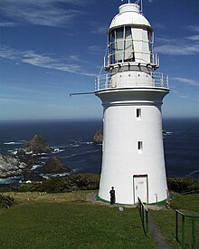
 Maatsuyker Island Lighthouse and the Needle Rocks on a clear day in December 2005. | |
 | |
| Location | Maatsuyker Island Tasmania Australia |
|---|---|
| Coordinates | 43°39′25″S 146°16′17″E / 43.656952°S 146.271518°E |
| Tower | |
| Constructed | 1891 (first) |
| Construction | brick tower (first) fiberglass tower (current) |
| Height | 15 metres (49 ft) (first) |
| Shape | conical tower with balcony and lantern (first) |
| Markings | white tower and lantern |
| Operator | Australian Maritime Safety Authority |
| Heritage | listed on the Tasmanian Heritage Register |
| Light | |
| First lit | 1996 (current) |
| Deactivated | 1996 (first) |
| Focal height | 140 metres (460 ft) (current) |
| Lens | First order Fresnel by Chance Brothers |
| Range | 26 nautical miles (48 km; 30 mi) (first) |
| Characteristic | Fl W 7.5 s. except every fourth flash omitted |
Maatsuyker Island Lighthouse is a lighthouse on Maatsuyker Island, Tasmania, Australia.[1] It was the last Australian lighthouse still being officially operated by lightkeepers. A second, smaller, and automated lighthouse was installed in 1996 but it is unclear whether volunteers are going to continue to work the lights on Maatsuyker Island.
- ^ "Maatsuyker Island Lighthouse". Lighthouses of Australia Inc. 29 January 2018. Retrieved 15 October 2019.