 Aerial view of the group from the west. Needle Rocks is on the right and to the left of them is Maatsuyker Island. De Witt is the larger island on the left. Tasmania and the South East Cape are in the background. The view was computer generated from satellite data using NASA World Wind. | |
| Etymology | Joan Maetsuicker[1] |
|---|---|
| Geography | |
| Location | Southern Tasmania |
| Coordinates | 43°38′24″S 146°16′12″E / 43.64000°S 146.27000°E |
| Total islands | 8-12 (depending on sources) |
| Major islands | |
| Administration | |
Australia | |
| State | Tasmania |
| Region | Southern |
| Demographics | |
| Population | Unpopulated |


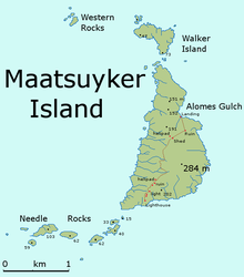
The Maatsuyker Islands are a group of islands and rocks 5.5 kilometres (3.4 mi) off the south coast of Tasmania, Australia. Maatsuyker Island is the southernmost island of the group and of the Australian continental shelf. There are exposed rocks further south of Maatsuyker but they do not meet the definition of "islands". Macquarie Island, far to the south, is also Australian territory but it is an upthrust piece of ocean floor in the remote Southern Ocean and is in a geological sense completely separate from the continent.
The group is noted for its rich marine wildlife, predominantly wet and windy weather conditions, and Australia's most southerly lighthouse. The group are contained within the Southwest National Park, part of the Tasmanian Wilderness World Heritage Site.[2]
- ^ Cite error: The named reference
heereswas invoked but never defined (see the help page). - ^ "Map of the Tasmanian Wilderness WHA". Visitor's Guide. Parks & Wildlife Service Tasmania. Archived from the original on 7 September 2007. Retrieved 16 October 2009.
