| Macclesfield | |
|---|---|
| Town | |
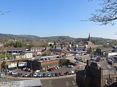
 Skyline of Macclesfield, with the railway station in the foreground, the spire of St Paul's Church in the background and townscape | |
Location within Cheshire | |
| Population | 57,539 |
| OS grid reference | SJ9173 |
| • London | 148 mi (238 km)[1] SE |
| Civil parish |
|
| Unitary authority | |
| Ceremonial county | |
| Region | |
| Country | England |
| Sovereign state | United Kingdom |
| Post town | MACCLESFIELD |
| Postcode district | SK10, SK11 |
| Dialling code | 01625 |
| Police | Cheshire |
| Fire | Cheshire |
| Ambulance | North West |
| UK Parliament | |
| Website | macclesfield-tc |

Macclesfield (/mækəlzfiəld/) is a market town and civil parish in the unitary authority of Cheshire East, Cheshire, England. It is sited on the River Bollin and the edge of the Cheshire Plain, with Macclesfield Forest to its east; the town lies 16 miles (26 km) south of Manchester and 38 miles (61 km) east of Chester.
Before the Norman Conquest, Macclesfield was held by Edwin, Earl of Mercia and was assessed at £8. The medieval town grew up on the hilltop around what is now St Michael's Church. It was granted a charter by Edward I in 1261, before he became king. Macclesfield Grammar School was founded in 1502. The town had a silk-button industry from at least the middle of the 17th century and became a major silk-manufacturing centre from the mid-18th century. The Macclesfield Canal was constructed in 1826–31.
Hovis breadmakers were another Victorian employer; modern industries include pharmaceuticals, such as Astra Zeneca. Multiple mill buildings are still standing and several of the town's museums explore the local silk industry. Other landmarks include Georgian buildings such as the Town Hall and former Sunday School; St Alban's Church, designed by Augustus Pugin; and the Arighi Bianchi furniture shop.
The population of Macclesfield at the 2021 census was 57,539. A person from the town is referred to as a Maxonian.[2][a]
- ^ "Coordinate Distance Calculator". boulter.com. Archived from the original on 9 March 2016. Retrieved 8 March 2016.
- ^ New Society, vol. 9, New Society Limited, 1967, p. 933
Cite error: There are <ref group=lower-alpha> tags or {{efn}} templates on this page, but the references will not show without a {{reflist|group=lower-alpha}} template or {{notelist}} template (see the help page).
