Machico | |
|---|---|
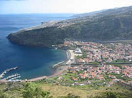
 The town of Machico in the shadow of the International Airport in Santa Cruz | |
 Location in Madeira | |
| Coordinates: 32°42′N 16°46′W / 32.700°N 16.767°W | |
| Country | |
| Auton. region | Madeira |
| Island | Madeira |
| Established | Settlement: c.1420 Municipality: c.1451 City: 2 August 1996 |
| Parishes | 5 |
| Government | |
| • President | Ricardo Miguel Nunes Franco |
| Area | |
| • Total | 68.33 km2 (26.38 sq mi) |
| Population (2011) | |
| • Total | 21,828 |
| • Density | 320/km2 (830/sq mi) |
| Time zone | UTC+00:00 (WET) |
| • Summer (DST) | UTC+01:00 (WEST) |
| Postal code | 9200-099 |
| Area code | 291 |
| Patron | Nossa Senhora da Conceição |
| Local holiday | 8 May[1] |
| Website | http://cm-machico.pt/ |
Machico (Portuguese pronunciation: [mɐˈʃiku] ) is a municipality, parish and city in the southeast part of the island of Madeira, in the Autonomous Region of Madeira. The easternmost municipality on the island, it is also the third-most populous area with a population of 21,828 in 2011.[2] The town, proper, had a population of 10,894 in 2001.[3]
- ^ "EDITAL 022 DE 2019 - ALTERAÇÃO DO FERIADO MUNICIPAL (DIA DO CONCELHO)". Retrieved 30 August 2022.
- ^ Instituto Nacional de Estatística
- ^ UMA POPULAÇÃO QUE SE URBANIZA, Uma avaliação recente – Cidades, 2004 Archived 6 October 2014 at the Wayback Machine Nuno Pires Soares, Instituto Geográfico Português (Geographic Institute of Portugal)

