| Mechoi Peak | |
|---|---|
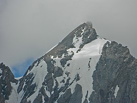
 Mechoi Peak, as seen on an overcast day, in 2013. | |
| Highest point | |
| Elevation | 5,393 m (17,694 ft) |
| Coordinates | 34°15′26″N 75°32′08″E / 34.25722°N 75.53556°E |
| Geography | |
 | |
| Parent range | Himalaya |
| Climbing | |
| First ascent | 10 September 1984 Indian army Team |
| Easiest route | Right side of Amarnath cave |
Mechoi Peak is a mountain with a peak elevation of 17,694 ft (5,393 metres), in Drass region of Ladakh,India. Mechoi Peak is part of the Himalaya Range, and is located between Amarnath cave and Zojila. It lies 105 km north east from Srinagar, 25 km from Sonamarg in the east and 30 km from Drass. It rises from the glacier of its name Mechoi Glacier and is the source of Dras River in Drass, Ladakh. Mechoi Peak rises from the Mechoi glacier and is a pyramid-shaped peak with ice falls and ice fields at its bottom and ridges.[1][2]
- ^ "SONAMARG AS A CLIMBING CENTRE. : Himalayan Journal vol.02/7". www.himalayanclub.org. Retrieved 28 January 2019.
- ^ "Geography of Kashmir". kousa.org. Retrieved 25 April 2012.


