Mackenzie District | |
|---|---|
 | |
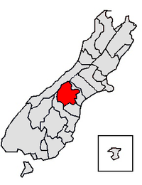
 Mackenzie District within the South Island | |
| Coordinates: 43°58′44″S 170°27′25″E / 43.979°S 170.457°E | |
| Country | New Zealand |
| Island | South Island |
| Region | Canterbury |
| Communities |
|
| Wards |
|
| Formed | 1989 |
| Seat | Fairlie |
| Government | |
| • Mayor | Anne Munro |
| • Deputy Mayor | Karen Morgan |
| • Territorial authority | Mackenzie District Council |
| Area | |
| • Total | 7,339.23 km2 (2,833.69 sq mi) |
| • Land | 7,138.59 km2 (2,756.23 sq mi) |
| Population (June 2023)[1] | |
| • Total | 5,690 |
| • Density | 0.78/km2 (2.0/sq mi) |
| Postcode(s) | |
| Website | www |
Mackenzie District is a local government district on New Zealand's South Island, administered by the Mackenzie District Council. It is part of the larger Canterbury Region. The region takes its name from the Mackenzie Basin, an elliptical intermontane basin which covers much of inland Canterbury.
- ^ "Subnational population estimates (RC, SA2), by age and sex, at 30 June 1996-2023 (2023 boundaries)". Statistics New Zealand. Retrieved 25 October 2023. (regional councils); "Subnational population estimates (TA, SA2), by age and sex, at 30 June 1996-2023 (2023 boundaries)". Statistics New Zealand. Retrieved 25 October 2023. (territorial authorities); "Subnational population estimates (urban rural), by age and sex, at 30 June 1996-2023 (2023 boundaries)". Statistics New Zealand. Retrieved 25 October 2023. (urban areas)