| Mackinaw River | |
|---|---|
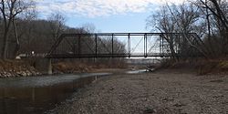
 Mackinaw River near Tremont, Illinois | |
 | |
| Physical characteristics | |
| Source | |
| • location | Ford County east of Sibley, Illinois |
| • coordinates | 40°35′20″N 88°21′59″W / 40.5889233°N 88.3664421°W |
| Mouth | |
• location | Confluence with the Illinois River near Mapleton, Illinois |
• coordinates | 40°33′06″N 89°43′56″W / 40.5517055°N 89.7323284°W |
• elevation | 443 ft (135 m) |
| Length | 130 mi (210 km) |
| Discharge | |
| • location | Green Valley, Illinois |
| • average | 772 cu/ft. per sec.[1] |
| Basin features | |
| Progression | Mackinaw River → Illinois → Mississippi → Gulf of Mexico |
| GNIS ID | 403283 |
The Mackinaw River is a 130-mile-long (210 km)[2] tributary of the Illinois River in the U.S. state of Illinois.[3] Its watershed covers approximately 1,136 square miles (3,000 km2),[4] and contains some of the most productive agricultural land in the United States. The river itself maintains some of the highest quality streams in the state and provides habitat for 60-70 native fish species and 25-30 species of mussels.[5] Its name, also spelled Mackinac, is derived from the Ojibwe word mikinaak meaning "turtle".[6]
- ^ "USGS Current Conditions for USGS 05568000 MACKINAW RIVER NEAR GREEN VALLEY, IL".
- ^ U.S. Geological Survey. National Hydrography Dataset high-resolution flowline data. The National Map Archived 2012-03-29 at the Wayback Machine, accessed May 13, 2011
- ^ U.S. Geological Survey Geographic Names Information System: Mackinaw River
- ^ Price, Alison L.; Shasteen, Diane K.; Bales, Sarah A. "Freshwater Mussels of the Mackinaw River: INHS Technical Report 2011 (45)" (PDF). Champaign, IL: Prairie Research Institute, University of Illinois at Urbana Champaign. Retrieved December 4, 2015.
- ^ "Mackinaw River". The Great Rivers Partnership. Retrieved December 4, 2015.
- ^ Nichols, John D.; Nyholm, Earl (1995). A Concise Dictionary of Minnesota Ojibwe. Minneapolis: University of Minnesota Press.