Macomb County | |
|---|---|
 Macomb County Administration Building in Mt. Clemens | |
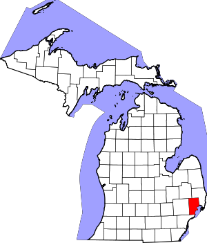
 Location within the U.S. state of Michigan | |
 Michigan's location within the U.S. | |
| Coordinates: 42°40′N 82°55′W / 42.67°N 82.91°W | |
| Country | |
| State | |
| Founded | January 15, 1818[1][2] |
| Named for | Alexander Macomb |
| Seat | Mount Clemens |
| Largest city | Warren |
| Area | |
| • Total | 571 sq mi (1,480 km2) |
| • Land | 479 sq mi (1,240 km2) |
| • Water | 92 sq mi (240 km2) 16% |
| Population (2020) | |
| • Total | 881,217 |
| • Estimate (2023) | 875,101 |
| • Density | 1,500/sq mi (600/km2) |
| Time zone | UTC−5 (Eastern) |
| • Summer (DST) | UTC−4 (EDT) |
| Congressional districts | 9th, 10th |
| Website | macombgov |
Macomb County (/məˈkoʊm/ mə-KOHM) is a county on the eastern shore of the U.S. state of Michigan. It is part of the Detroit metropolitan area, bordering Detroit to the north and containing many of its northern suburbs. Its seat of government is Mt. Clemens, and its largest community is Warren.[3] As of the 2020 census, the county had a population of 881,217, making it the third-most populous county in the state, behind neighboring Wayne and Oakland.[4]
Macomb County contains 27 cities, townships and villages, including three of the ten most-populous municipalities in Michigan. Most of this population is concentrated south of Hall Road (M-59), one of the county's main thoroughfares.
- ^ Cite error: The named reference
clarkewas invoked but never defined (see the help page). - ^ "Macomb County Home Page". macombgov.org. Archived from the original on October 2, 2006.
- ^ "Find a County". National Association of Counties. Retrieved June 7, 2011.
- ^ "State & County QuickFacts". United States Census Bureau. Retrieved September 14, 2021.
