| Macquarie Park Sydney, New South Wales | |||||||||||||||
|---|---|---|---|---|---|---|---|---|---|---|---|---|---|---|---|
 | |||||||||||||||
 | |||||||||||||||
| Population | 11,071 (SAL 2021)[1] | ||||||||||||||
| Established | 5 February 1999 | ||||||||||||||
| Postcode(s) | 2113 | ||||||||||||||
| Elevation | 52 m (171 ft) | ||||||||||||||
| Area | 6.8 km2 (2.6 sq mi) | ||||||||||||||
| Location | 15 km (9 mi) north-west of Sydney CBD | ||||||||||||||
| LGA(s) | City of Ryde | ||||||||||||||
| State electorate(s) | Ryde, Lane Cove | ||||||||||||||
| Federal division(s) | Bennelong | ||||||||||||||
| |||||||||||||||
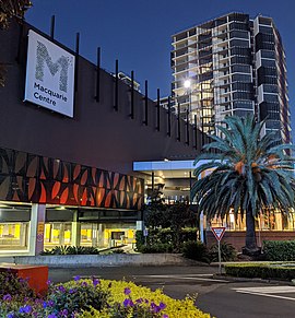
Macquarie Park (/məˈkwɒri/) is a suburb in the Northern Sydney region of Sydney, New South Wales, Australia. Macquarie Park is located 13 kilometres north-west of the Sydney central business district in the local government area of the City of Ryde.[2]
Macquarie Park was part of the suburb of North Ryde until it was gazetted as a suburb in its own right on 5 February 1999,[3] and many businesses still use North Ryde as the address. Both suburbs share the 2113 postcode but Macquarie University, which is located at the northern part of the suburb, has its own postcode of 2109.
- ^ Australian Bureau of Statistics (28 June 2022). "Macquarie Park (suburb and locality)". Australian Census 2021 QuickStats. Retrieved 28 June 2022.
- ^ "Strategic Employment Review: Macquarie Park" (PDF). BIS Shrapnel. 2015. Archived from the original (PDF) on 23 April 2023. Retrieved 8 October 2022.
- ^ "Macquarie Park (suburb)". Geographical Names Register (GNR) of NSW. Geographical Names Board of New South Wales. Retrieved 27 April 2014.