Macul | |
|---|---|
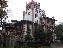
 Vásquez Palace, the town hall for the Municipality of Macul. | |
|
| |
| Coordinates (city): 32°39′30″S 70°36′00″W / 32.65833°S 70.60000°W | |
| Country | Chile |
| Region | Santiago Metro. |
| Province | Santiago |
| Government | |
| • Type | Municipality |
| • Alcalde | Gonzalo Montoya ([Independent]) |
| Area | |
| • Total | 12.9 km2 (5.0 sq mi) |
| Population (2002 Census)[3] | |
| • Total | 112,535 |
| • Density | 8,700/km2 (23,000/sq mi) |
| • Urban | 112,535 |
| • Rural | 0 |
| Sex | |
| • Men | 53,667 |
| • Women | 58,868 |
| Time zone | UTC-4 (CLT[4]) |
| • Summer (DST) | UTC-3 (CLST[5]) |
| Area code | 56 + |
| Website | Municipality of Macul |
Macul (Quechua: "to stretch out right hand") is a commune (smallest administrative subdivision in Chile) of Chile located in the central-eastern part of the Greater Santiago area, bordered by the communes of Ñuñoa to the north, San Joaquín to the west, Peñalolén to the east and La Florida to the south.
It is a predominantly residential and industrial zone, but its activities have been increasing and diversifying, which has forced a gradual change in terms of infrastructure and equipment. Most inhabitants are considered middle class.
- ^ "Municipality of Macul" (in Spanish). Retrieved 27 January 2011.
- ^ "Asociación Chilena de Municipalidades" (in Spanish). Retrieved 27 January 2011.
- ^ a b c "National Statistics Institute" (in Spanish). Retrieved 13 December 2010.
- ^ "Chile Time". WorldTimeZones.org. Archived from the original on 11 September 2007. Retrieved 29 July 2010.
- ^ "Chile Summer Time". WorldTimeZones.org. Archived from the original on 11 September 2007. Retrieved 29 July 2010.


