| Madagascar lowland forests | |
|---|---|
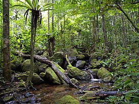
 Humid forest in Masoala National Park | |
 | |
| Ecology | |
| Realm | Afrotropical |
| Biome | Tropical and subtropical moist broadleaf forests |
| Borders | Madagascar subhumid forests, Madagascar spiny forests |
| Animals | Lemurs, chameleons, Mantella frogs |
| Geography | |
| Area | 112,100 km2 (43,300 sq mi) |
| Country | Madagascar |
| Elevation | 0–800 metres (0–2,625 ft) |
| Coordinates | 19°48′S 48°30′E / 19.800°S 48.500°E |
| Geology | Metamorphic and igneous basement rock; locally lava and unconsolidated sands |
| Climate type | Tropical rainforest climate (Af) and Tropical monsoon climate (Am) |
| Conservation | |
| Conservation status | critical/endangered |
| Global 200 | included |
| Protected | 10.79%[1] |
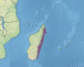
The Madagascar lowland forests or Madagascar humid forests[2] are a tropical moist broadleaf forest ecoregion found on the eastern coast of the island of Madagascar, home to a plant and animal mix that is 80 to 90% endemic, with the forests of the eastern plain being a particularly important location of this endemism. They are included in the Global 200 list of outstanding ecoregions.[3][1][4]
- ^ a b "Madagascar lowland forests". Digital Observatory for Protected Areas. Retrieved 4 September 2022.
- ^ Cite error: The named reference
Crowley2004-humid-forestswas invoked but never defined (see the help page). - ^ "Map of Ecoregions 2017". Resolve. Retrieved August 20, 2021.
- ^ "Madagascar lowland forests". The Encyclopedia of Earth. Retrieved August 20, 2021.